 The Quittapahilla Watershed
Probably the best description we have of the "big picture" view of the Quittapahilla watershed comes from a 2012 design report by Rocky Powell, President of Clear Creeks Consulting LLP, who has walked every mile of the Quittie & knows the watershed better than anyone:
"The Quittapahilla Creek Watershed is situated in the Ridge and Valley physiographic region in Lebanon County, Pennsylvania. Quittapahilla Creek is a tributary to Swatara Creek and is part of the Susquehanna River Basin. Its headwaters begin just southeast of Lebanon, Pennsylvania and it enters the Swatara Creek near North Annville, Pennsylvania. From its headwaters south of the City of Lebanon (elevation 500 feet) Quittapahilla Creek flows approximately 22 stream miles to its confluence with Swatara Creek in the North Annville Township (elevation 350 feet). . . .
"The majority of the land area in the watershed is situated in the Great Valley section of the Ridge and Valley region. This area is underlain by bedrock of Lower Paleozoic shale, limestone, and dolomite formations. The upper and middle reaches of the mainstem Quittapahilla Creek as well as the middle and lower reaches of the major tributaries flow across the carbonate rocks of the valley. Sinkholes and solution cavities are common in these carbonate rocks. Quarries in the carbonate rock are mined for concrete aggregate, cement, flux stone, and paint filler. . . . " (Powell, May 2012 Design Report, Quittie Nature Park Stream Restoration Project).
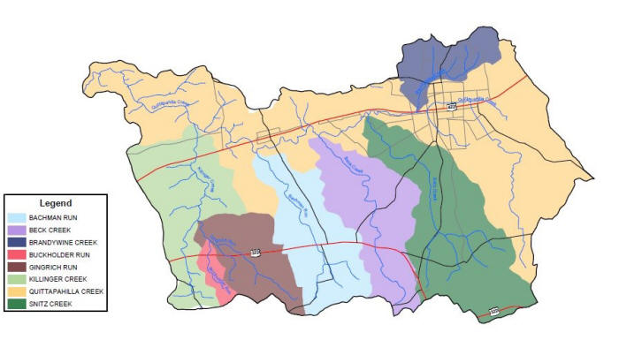
Below: Principal subwatersheds of the Quittapahilla watershed, adapted from Powell, "Findings Report," vol. 1 (2006), Plate 2.
The Quittapahilla watershed runs through rich & intensely cultivated agricultural land to the south and relatively dense urban zones to the north, with the main branch — the Quittapahilla Creek — paralleling a major east-west highway that runs from Lebanon to Hershey (Route 422). Fed by rainfall and thousands of natural springs, the waterways making up the Quittapahilla watershed swell with each rainstorm and ebb during dry spells, but always flow powerfully. The Quittie abounds in fresh natural springs and the creek's waters feel chillingly cold year-round.
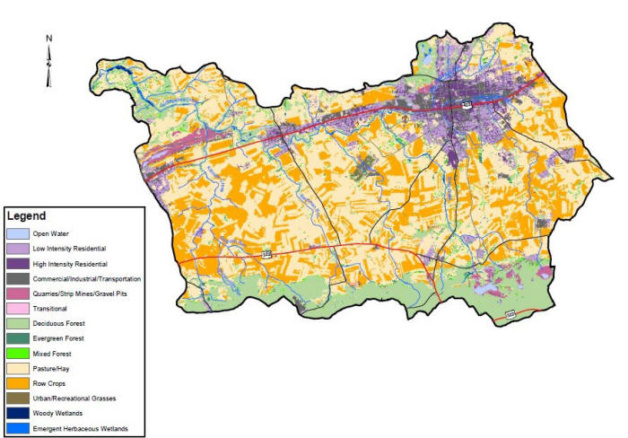
Below: Land Use Map of the Quittapahilla Watershed, adapted from Powell, vol. 1 (2006), Plate 8.
In 1972, the newly created Pennsylvania Department of Environmental protection described Quittapahilla Creek as an "open sewer" in consequence of all the agricultural & industrial effluents contaminating the watershed, and recommended against stocking the creek with trout. Since that time the watershed's water quality has improved to a degree. Introduced trout are now breeding in some sections, and smaller native fish are making a comeback. But the Quittie & its main tributaries remain highly vulnerable to human contaminants. Severely injured by decades of human contamination, toxins & neglect, the watershed needs the help of humans to nurture it back to health.
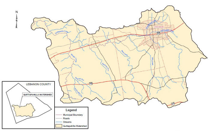
Below: Quittapahilla Watershed, adapted from Powell, vol. 1 (2006), Plate 1.
The links to the left offer more detailed looks at each of the principal waterways comprising the watershed, starting with the main artery and the most urbanized, polluted & damaged, Quittie Creek.