The arrow on the Google Map below points to the source of Quittapahilla Creek in a small wetlands on the east side of Lebanon. Zoom in using the navigation tools to the left, or click on "View Larger Map" at the bottom.
View Larger Map
.jpg) The
word
Quittapahilla is an an
anglicized corruption of an Algonquin Indian phrase
meaning "a stream that flows from the ground among
the pines." (The image of the plaque at
right is from the Lebanon Valley College campus,
next to the Neidig-Garber Science Building &
adjacent to the large green & gold statue of an
indigenous woman that its creator, the sculptor &
artist Audrey Flack, called "Cuewe-Pehelle").
The
word
Quittapahilla is an an
anglicized corruption of an Algonquin Indian phrase
meaning "a stream that flows from the ground among
the pines." (The image of the plaque at
right is from the Lebanon Valley College campus,
next to the Neidig-Garber Science Building &
adjacent to the large green & gold statue of an
indigenous woman that its creator, the sculptor &
artist Audrey Flack, called "Cuewe-Pehelle").
Quittapahilla Creek still flows from the ground, and even today some small sections flow among the pines. But the Quittie in its upper reaches has become mainly an urban river, flowing through urban spaces and receiving a continuous flow of contaminants & pollutants from the area's streets, alleys, driveways & parking lots.
 In the words of Clear Creeks Consulting
LLC President
Rocky Powell:
In the words of Clear Creeks Consulting
LLC President
Rocky Powell:
"Quittapahilla Creek starts as a small spring on a dairy farm in the South Lebanon Township. [Photo at left.] The surrounding land that drains the headwaters to the south and east is still fairly rural and includes large farms with cropland and pasture. However, as the Quittapahilla flows north toward the City of Lebanon farmland quickly gives way to residential subdivisions and commercial properties.
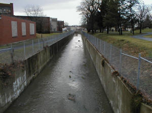
"Flowing beneath Route 422 the creek turns west and flows through the center of Lebanon. Storm drains carry runoff from densely developed neighborhoods to the north and south into a highly altered channel that was first modified in the 18th century. As a result of the flood mitigation projects that the City initiated in the late 1970’s Quittapahilla Creek is conveyed in a concrete flume from 3rd Street to 19th Street. [a.k.a. Flynn's Hazel Dike; see photo below right.] The land on either side of the channel includes typical urban uses characterized by high percent impervious surfaces all routed via storm drains to the creek. After leaving the City of Lebanon the creek flows in a direction that roughly parallels the intensely developed corridor along Route 422 through West Lebanon, Cleona, and Annville.
 "On its
way west it meanders along its natural
floodplain where a surprising amount of area
has been maintained in forest cover in spite
of the adjacent land use. These wooded areas
are most often associated with steep, rocky
slopes or wet seeps and springs, and other
areas with saturated soil conditions.
"On its
way west it meanders along its natural
floodplain where a surprising amount of area
has been maintained in forest cover in spite
of the adjacent land use. These wooded areas
are most often associated with steep, rocky
slopes or wet seeps and springs, and other
areas with saturated soil conditions.
"With the exception of the Lebanon Wastewater Treatment Plant, cropland is the predominant land use along the left (south) floodplain and adjacent slopes. In some areas crops have been planted to within a few feet of the bank. Land use along the right (north) floodplain and adjacent slopes is more variable and includes old and new residential subdivisions, parking lots of businesses that front on Route 422, schools and athletic fields.
"At the western end of Annville the Quittapahilla Creek flows under Route 422 and heads in a northwest direction. Immediately downstream of the Annville Wastewater Treatment Plant the creek enters a concrete flume that conveys it through a land area pocked with abandoned quarries. The creek empties into a natural channel on a large farm upstream of Clear Spring Road. From this point to its confluence with Swatara Creek, farms and homesteads on large parcels border the Quittapahilla."
As Powell's description makes clear, the Quittie is mainly an urban river from its origins on the east side of Lebanon to the west side of Annville. This is what makes the remaining small sections where the Quittie does "flow through the pines," as it does in Quittie Creek Nature Park, so precious & vulnerable.
Stream Length: 22
miles (source to mouth)
Elevation at Origin: 508.5 ft.
Elevation at End: 364.2 ft.
For more information on Quittie Creek Nature Park in Annville, please visit the Friends of Old Annville website (offsite).
For additional images of Quittapahilla Creek & its principal tributaries, see the Photos & Images pages.