This is the homepage for a series of web pages devoted to pipeline development in Lebanon County and the surrounding region. It is a page that the County Commissioners' Office ought to keep, and hopefully will soon, if the ongoing dialogue between the County Commissioners and the grassroots citizens' organization Lebanon Pipeline Awareness bear some fruit. Meantime the information needs to get out there. These pages were created to house this information for easy public access.
In what follows we offer a kind of model or template from which the County Commissioners' office can feel free to draw. We claim no authorship; indeed, we openly borrow from other websites, with attribution — starting with the organization of the page into 10 sections, a scheme borrowed from the Chester County Pipeline Information Center, whose designers & builders we thank for their excellent work.
Welcome to the Lebanon County Pipeline Information Center! Our goal in these pages is to provide citizens, residents, and visitors with an authoritative, up to date, and easy to access repository of information relating to pipelines in Lebanon County. We welcome your comments and suggestions as we build these web pages, which are divided into the following 10 categories:
1. Upcoming Events & Pipeline Pages Overview
4. Glossary of Terms & Acronyms
10. Resources
1. Upcoming Events & Pipeline Pages Overview
This section offers a quick guide to upcoming events relating to pipelines in Lebanon County, including public meetings at which pipeline issues are on the agenda or likely to be discussed. Please check the box below for regular updates on upcoming events and public meetings.
|
Upcoming Pipeline-Related Events & Public Meetings in Lebanon County Sample Event 1. This is the digital space envisioned for keeping the public apprised of pipeline-related events & public meetings in Lebanon County. Sample Event 2. See above. Et cetera. |
There are currently two principal active pipeline projects in Lebanon County: Sunoco Logistics' Mariner East Projects, and Williams Partners' proposed Atlantic Sunrise Project. We briefly summarize each below.
1. Sunoco Logistics' Mariner East Projects.
There are three Mariner East Projects, only the first of which is operational at the present writing: Mariner East 1. Expansion plans along the same easement include Mariner East 2 and Mariner East 3.
Mariner East 1. The map below shows the existing 8-inch diameter, cast iron Mariner East 1 pipeline, which dates to the mid-1930s, with a capacity of 70,000 barrels per day (map taken from PennLive.com, 6 Nov. 2014):
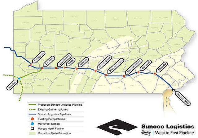
The Cornwall Pump Station, shown in the map above, is located near the intersection of Route 322 (Horseshoe Pike) and Butler Road in West Cornwall Township. As PennLive accurately summarized in its story of 6 Nov. 2014, "Mariner East I is an existing oil pipeline that Sunoco plans to retrofit to transport natural gas products, propane and ethane, east from Marcellus Shale natural gas processing centers in western Pennsylvania with Sunoco Logistics' Marcus Hook facility near Philadelphia."
Starting in the 1930s, the 8-inch diameter, cast iron pipeline carried gasoline from refineries in the Philadelphia area to western PA and Ohio. In late 2012, Sunoco shut down the pipeline to begin a conversion process that would reverse the flow and permit ethane, propane, and other NGLs to flow from the fracking zones of Ohio and western PA to refineries on the East Coast. By late 2014, the conversion process was mostly completed.
Mariner East 2. The $2.5 billion Mariner East 2 project is planned to use the same right-of-way to expand Mariner East 1's capacity to carry natural gas liquids (NGLs) from the fracking zones to processing facilities at the Marcus Hook Complex near Philadelphia. As summarized in the Oil & Gas Journal on 7 Nov. 2014, "Mariner East 2 is the second phase of the company’s broader plan to transport [an additional] 275,000 barrels per day of various NGLs (propane, butane, and ethane) from processing and fractionation complexes in the Marcellus and Utica shale areas in western Pennsylvania, West Virginia, and eastern Ohio to Sunoco Logistics’ 800-acre Marcus Hook Industrial Complex (MHIC) in southeastern Pennsylvania." (Oil & Gas Journal, 7 Nov. 2014). Sunoco expects Mariner East 2 to be fully operational by the end of 2016.
Mariner East 3. In December 2014, Sunoco spokesman Jeffrey Shields denied reports that the company was planning a further expansion of pipeline capacity via Mariner East 3 (see TribLive, 15 Dec. 2014).
Additional content is forthcoming.
2. Williams Partners' proposed Atlantic Sunrise Project.
Content in progress.
As noted above, there are currently two principal active pipeline projects in Lebanon County, one east-west and the other north-south: Sunoco's Mariner East Projects, and Williams' Atlantic Sunrise Project. We begin here with the north-south project, the proposed Atlantic Sunrise pipeline.
1. The Proposed Atlantic Sunrise Pipeline Project
Below is the proposed route of the Atlantic Sunrise pipeline, borrowed from the website LancasterPipeline.org and last updated on 17 December 2014. The map shows the entire Central Penn Line South, though some details are incorrect, such as the current siting of the pipeline across Route 422 just west of Annville.
Additional content is forthcoming.
4. Glossary of Terms & Acronyms
The following terms & acronyms are useful in understanding the engineering and legal terms used in the planning, construction, and repair of pipelines. These definitions were taken from the glossary presented in the Pipelines and Informed Planning Alliance Final Report of Recommended Practices (PIPA), published in November 2010 by the United States Department of Transportation, Pipeline and Hazardous Materials Safety Administration, Office of Pipeline Safety. We thank the Chester County Pipeline Information Center for its Glossary, at http://www.landscapes2.org/pipeline/Glossary.cfm, from which most of this information was taken.
GLOSSARY OF TERMS:
Abandoned Pipeline: A transmission pipeline that has been permanently removed from service and left in place.
As–Built Drawing: A detailed drawing or set of drawings depicting the actual configuration of installed or constructed facilities.
Backfill: The act of filling in the void in a utility ditch that was created by excavating, usually by replacing the soils that were removed. Also, the material used to fill the ditch.
Building Setback: See "Setback"
Cathodic Protection: The process of arresting corrosion on a buried or submerged metallic structure, by electrically reversing the natural chemical reaction. This includes, but is not limited to, installation of a sacrificial anode bed, use of a rectifier based system, or any combination of these or other similar systems. Wiring is installed between the buried or submerged structure and all anodes and rectifiers. Wiring is also installed to test stations which are used to measure the effectiveness of the cathodic protection system.
Consultation Zone: An area extending from each side of a transmission pipeline, the distance of which should be defined by local governments, to describe when a property developer/owner, who is planning new property development in the vicinity of an existing transmission pipeline, should initiate a dialogue with a transmission pipeline operator.
Damage: Any impact or exposure that results in the need to repair an underground facility due to a weakening or the partial or complete destruction of the facility, including, but not limited to, the protective coating, lateral support, cathodic protection or the housing for the line, device or facility.
Demolition: The partial or complete destruction by any means of a structure served by, or adjacent, to an underground line or facility. Designer – Any architect, engineer or other person who prepares or issues a drawing or blueprint for a construction or other project that requires excavation or demolition work.
Developer: An individual or group of individuals who apply for permits to alter, construct and install buildings or improvements or change the grade on a specific piece of property.
Distribution Pipeline: A natural gas pipeline other than a gathering or transmission line (reference 49 CFR 192.3). A distribution pipeline is generally used to supply natural gas to the consumer and is found in a network of piping located downstream of a natural gas transmission line.
Easement: (1) A legal instrument giving a transmission pipeline operator a temporary or permanent right to use a right–of–way for the construction, operation, and maintenance of a pipeline. It may also include temporary permits, licenses, and other agreements allowing the use of one's property. (2) An easement is an acquired privilege or right, such as a right–of–way, afforded a person or company to make limited use of another person or company's real property. For example, the municipal water company may have an easement across your property for the purpose of installing and maintaining a water line. Similarly, oil and natural gas pipeline companies acquire easements from property owners to establish rights–of–way for construction, maintenance and operation of their pipelines. (3) A legal right, acquired from a property owner, to use a strip of land for installation, operation and maintenance of a transmission pipeline.
Emergency Preparedness: The act or state of being prepared to respond to and handle a pipeline emergency. Pipeline operators are required to have emergency preparedness programs, plans, and procedures in place to implement during pipeline emergencies.
Emergency Response: The actual response taken to address an emergency. The response to a pipeline emergency should be consistent with the pipeline operator's and other emergency responders' programs, plans, and procedures.
Encroachment: (1) A human activity, structure, facility, or other physical improvement that intrudes onto a transmission pipeline right–of–way. (2) Encroachment refers to the unauthorized use of a right–of–way in violation of the easement terms.
Excavation: Any operation using non–mechanical or mechanical equipment or explosives in the movement of earth, rock or other material below existing grade. This includes, but is not limited to, augering, blasting, boring, digging, ditching, dredging, drilling, driving–in, grading, plowing–in, pulling–in, ripping, scraping, trenching, and tunneling.
Excavator: Any person proposing to, or engaging in, excavation or demolition work for himself or for another person.
Facility Operator: Any person, utility, municipality, authority, political subdivision or other person or entity who operates or controls the operation of an underground line/facility.
Facility: A buried or aboveground conductor, pipe, or structure used to provide utility services, such as electricity, natural gas, liquids refined from oil, oil, telecommunications, water, sewerage, or storm water.
Feather Cut: A method to trim trees to create a natural looking profile. (Also see Hard Cut.)
Gas: Natural gas, flammable gas, or gas which is toxic or corrosive. (Reference 49 CFR 192.3) Gases are normally compared to air in terms of density. The specific gravity of air is 1.0. Any gas with a specific gravity less than 1.0 (such as natural gas) will rise and usually disperse. Any gas having a specific gravity greater than 1.0 will fall and collect near the ground or in low–lying areas such as trenches, vaults, ditches, and bell holes – such occurrences can be hazardous to human health and safety.
Gas Transmission Pipeline: A pipeline, other than a gathering line, that 1) transports gas from a gathering line or storage facility to a distribution center, storage facility, or large-volume customer that is not downstream from a distribution center; 2) operates at a hoop stress of 20 percent or more of specified minimum yield strength; or, 3) transports gas within a storage field. (Reference 49 CFR 192.3) A gas transmission pipeline includes all parts of those physical facilities through which gas moves in transportation, including pipe, valves, and other appurtenance attached to pipe, compressor units, metering stations, regulator stations, delivery stations, holders, and fabricated assemblies.
Geographic Information System (GIS): An organized collection of computer hardware, software, and geographic data used to capture, store, update, maintain, analyze, and display all forms of geographically referenced information.
Hard Cut: A method to trim trees to create an abrupt, clearly delineated boundary. (Also see Feather Cut.)
Hazardous Liquid: Includes petroleum, petroleum products, anhydrous ammonia, and carbon dioxide. (Reference 49 CFR 195.2)
Hazardous Liquid Pipeline: All parts of a pipeline facility through which a hazardous liquids move in transportation, including, but not limited to, line pipe, valves, and other appurtenances connected to line pipe, pumping units, fabricated assemblies associated with pumping units, metering and delivery stations and fabricated assemblies therein, and breakout tanks.
High Consequence Area: A location that is specially defined in pipeline safety regulations as an area where transmission pipeline releases could have greater consequences to health and safety or the environment. Regulations require a transmission pipeline operator to take specific steps to ensure the integrity of a transmission pipeline for which a release could affect an HCA and, thereby, the protection of the HCA.
High–Priority Subsurface Installation: Sometimes referred to as high-priority underground installation, these include natural gas transmission pipelines operating at a pressure that creates a hoop stress of 20% or more of the steel specified minimum yield strength, hazardous liquid pipelines, high voltage electric supply lines, fiber optic lines, pressurized sewage pipelines, and other hazardous underground installations.
Incident: An unintentional release of product from a transmission pipeline that may or may not result in death, injury, or damage to property or the environment. (Note that as used in pipeline safety regulations, an "incident" is an event occurring on a natural gas pipeline for which the operator must make a report to PHMSA's Office of Pipeline Safety. Events of similar magnitude affecting hazardous liquid pipelines are considered "accidents". (Reference 49 CFR 191.3, 49 CFR 195.50).
Line pipe: The lengths of pipe comprising the main part of transmission pipeline segments, line pipe is identified as only the pipe, excluding ancillary facilities and structures that are located on company property adjacent to the pipeline ROW.
Locate: The process of determining the existence and location of an underground facility, such as an oil or gas pipeline. Following the locate, the surface of the ground above the underground installation is normally marked through the use of stakes, flags or paint, or in some other customary manner. Such markings identify the location of the underground facility so that excavators can avoid damage to the facility when digging.
Locate Request: A communication between an excavator and one–call center personnel in which a notice of proposed excavation and request for locating underground facilities is processed. The one–call center subsequently passes this information to underground facility owners based on the location of the proposed excavation and underground facility data.
MAOP: See Maximum Allowable Operating Pressure.
Mark: To indicate the existence and location of a line or facility by establishing a mark through the use of stakes, paint or some other customary manner.
Maximum Allowable Operating Pressure: The maximum pressure at which a gas transmission pipeline or segment of a pipeline may be operated under federal pipeline safety regulations (29 CFR Part 192).
Mitigation: Actions taken to alleviate, reduce the severity of, or moderate the consequences of failure.
NPMS: National Pipeline Mapping System – a geographic information system (GIS) database that contains the locations and attributes of hazardous liquid and gas transmission pipelines operating in the United States. The NPMS also includes data on the locations of other geographic features throughout the U.S. The NPMS supports queries by the public and local governments to determine if transmission pipelines are located near their communities and to determine areas that could be impacted by releases from these pipelines. The NPMS may be accessed at http://www.npms.phmsa.dot.gov/.
One–Call Center: An entity that administers a one–call system through which a person can notify transmission pipeline operators of proposed excavations.
One–Call System: A system that enables an excavator to communicate through a one–call center to transmission pipeline operators to provide notification of intent to excavate. The one–call center will gather information about the intended excavation and then issue tickets to notify affected member transmission pipeline operators. The operators can then clear the tickets or locate and mark the location of their pipelines before the excavation begins. Excavators can then take care when excavating to avoid damaging the transmission pipelines. All 50 states within the U.S. are covered by one–call systems. Most states have laws requiring the use of the one–call system at least 48 hours before beginning an excavation.
Ordinance: An authoritative public rule, law or regulation, such as a zoning ordinance, issued by a local community government. A zoning ordinance is a device of land use planning used by local governments to designate permitted uses of land based on mapped zones which separate one set of land uses from another. Zoning may be use-based (regulating the uses to which land may be put), or it may regulate building height, lot coverage, and similar characteristics, or some combination of these.
Petroleum Products: Flammable, toxic, or corrosive products obtained from distilling and processing of crude oil, unfinished oils, natural gas liquids, blend stocks and other miscellaneous hydrocarbon compounds.
Pipeline: Used broadly, pipeline includes all parts of those physical facilities through which gas, hazardous liquid, or carbon dioxide moves in transportation.
Pipeline Easement: See "Easement".
Pipeline Operator: For natural gas transmission pipelines, a person who engages in the transportation of gas (reference 49 CFR 192.3). For hazardous liquid pipelines, a person who owns or operates pipeline facilities (reference 49 CFR 195.2). Generally, an operator is a company or person responsible for the operation, maintenance and management of the transmission pipeline.
Pipeline Segment: A discrete portion of a transmission pipeline system as defined by the pipeline operator. A pipeline segment usually consists of a length of line pipe and may contain ancillary structures and other appurtenances associated with the pipeline. The end points defining the boundaries of a pipeline segment are usually determined by geographic features (e.g., mile posts) and/or features of the pipeline itself, such as welds, valves, etc.
Planning: An activity at the beginning of a project where information is gathered and decisions are made regarding the route or location of a proposed excavation based on constraints including the locations of existing facilities, anticipated conflicts and the relative costs of relocating existing facilities or more expensive construction for the proposed facility.
Planning Area: An area surrounding a transmission pipeline that is defined by ordinance and is based on characteristics of the pipeline and the area surrounding the pipeline. Local governments and property developers/owners should consider implementing a planning area to protect communities where new development is planned near transmission pipelines.
Plat: A map or representation on paper of a piece of land subdivided into lots, with streets, alleys, etc., usually drawn to a scale.
Project: An activity or task (or set of related activities or tasks) that is contemplated, devised, or planned and carried out for the purpose of accomplishing a goal. For example, a communication project could involve a planned set of activities to communicate the PIPA recommended practices to affected stakeholders. Usually thought of as affecting construction, maintenance or development activities, projects that could affect a transmission pipeline could be as simple as the planting of a tree or as complex as multi-million dollar construction projects.
Resolution: An expression of sentiment by a public or private entity. In the case of public entities like counties, townships, and boroughs, a resolution expresses the sentiment of the body that approves it, but unlike an ordinance, does not carry the force of law.
Right–Of–Way (ROW): (1) Property, usually consisting of a narrow, unobstructed strip or corridor of land of a specific width, which a pipeline company and the fee simple landowners have legal rights to use and occupy. A ROW is a string of contiguous properties on which easements have been acquired along which the pipeline operator has rights to construct, operate and maintain a pipeline. (2) A defined strip of land on which an operator has the right to construct, operate and maintain a pipeline. The operator may own a right–of–way outright or an easement may be acquired for specific use of the right–of–way. (Also see Rights-of-way.)
Right–Of–Way Agreement: See "Easement"
Rights-Of-Way: See "Right-of-way"
Risk: The product of the probability or likelihood of an undesired event occurring and the consequences that may result from that event.
Risk Informed: Having adequate knowledge of associated risk to be able to make appropriate decisions relative to the risk.
Risk Reduction: Measures taken to minimize the probability or likelihood and/or consequences of risk.
Rural: An area outside the limits of any incorporated or unincorporated city, town, village, or any other designated residential or commercial area such as a subdivision, a business or shopping center, or community development. (Reference 49 CFR 195.2)
Setback: The minimum distance between a pipeline or the edge of a pipeline easement, and a building or other structure. A line established by local government ordinance, within a property, defining the minimum distance between any building or structure or portion thereof to be erected or altered, and an adjacent right-of-way, street or property line. The setback is usually expressed as the minimum distance between the line of demarcation (e.g., a pipeline or the edge of a pipeline easement) and a building or other structure.
Temporary Work Space: An area of land within which certain activities are authorized for a specified purpose and period of time, typically of short duration.
Third–Party Damage: Third–party damage includes outside force damage to underground facilities (e.g., transmission pipelines) that can occur during excavation activities and is caused by someone other than the facility operator or its contractors.
Ton-Miles: Describes the units of measure to measure the quantity and traffic of transportation used in transportation statistics, planning, and their related fields. A ton-mile is equivalent to moving one ton of freight product one mile.
Transmission Pipeline: When not specified includes both hazardous liquid and gas transmission pipelines. Transmission pipelines carry oil, petroleum products, natural gas, natural gas liquids, anhydrous ammonia and carbon dioxide from producing regions of the country to markets.
Transmission Pipeline Corridor: A pipeline corridor is a linear area where two or more pipelines (either part of the same or different pipeline systems) are closely grouped in a single right–of–way.
Urban: 1) Relating to or concerned with a city or densely populated area (e.g., "urban development"); 2) Located in or characteristic of a city or city life (e.g., "urban property owners").
Vapor Pressure (also equilibrium vapor pressure): The pressure of a vapor in thermodynamic equilibrium with its condensed phases in a closed container. Said another way, the vapor pressure of a liquid is the pressure exerted by its vapor when the liquid and vapor are in dynamic equilibrium. All liquids and solids have a tendency to evaporate into a gaseous form, and all gases have a tendency to condense back to their liquid or solid form. The equilibrium vapor pressure is an indication of a liquid's evaporation rate. It relates to the tendency of particles to escape from the liquid (or a solid). A substance with a high vapor pressure at normal temperatures is often referred to as volatile.
Volatile Organic
Compounds (VOCs):
Organic
chemicals that have a
high vapor pressure at
ordinary room
temperature. Their high
vapor pressure results
from a low boiling
point, which causes
large numbers of
molecules to evaporate
or sublimate from the
liquid or solid form of
the compound and enter
the surrounding air.
VOCs include a variety
of chemicals, some of
which may have short-
and long-term adverse
health effects.
Improperly operated
natural gas flares may
emit methane and other
volatile organic
compounds as well as
sulfur dioxide and other
sulfur compounds, which
are known to exacerbate
asthma and other
respiratory problems.
Other emissions from
improperly operated
flares may include,
aromatic hydrocarbons
(benzene, toluene,
xylenes) and
benzapyrene, which are
known to be
carcinogenic.
GLOSSARY OF ACRONYMS:
AGA: American Gas Association
ALTA: American Land Title Association
APGA: American Public Gas Association
API: American Petroleum Institute
MapAPWA: American Public Works Association
BLM: U. S. Department of Interior, Bureau of Land Management
CFR: Code of Federal Regulations
CGA: Common Ground Alliance
DOT (or US DOT): United States Department of Transportation
FERC: Federal Energy Regulatory Commission
GPA: Gas Producers Association
HCA: high consequence area
INGAA: Interstate Natural Gas Association of America
LNG: Liquefied Natural Gas
LPA: Lebanon Pipeline Awareness, Inc.
MAOP: Maxium Allowable Operating Pressure
MLS: multiple listing service
NACo: National Association of Counties
NAHB: National Association of Home Builders
NAR: National Association of Realtors
NARUC: National Association of Regulatory Utility Commissioners
NASFM: National Association of State Fire Marshals
NATaT: National Association of Towns and Townships
NFPA: National Fire Protection Association
PIGNPMS: National Pipeline Mapping System
NTSB: National Transportation Safety Board
NPDES: National Pollutant Discharge Elimination System
OPS: US DOT Office of Pipeline Safety
PAPA-DEP: Pennsylvania Department of Environmental Protection
PA-DOT (or Penn-DOT): Pennsylvania Department of Transportation
PA-PUC: Pennsylvania Public Utilities Commission
PEMA: Pennsylvania Emergency Management Agency
PHMSA: Pipeline and Hazardous Materials Safety Administration, U. S. Department of Transportation
PIG: Pipeline Inspection Gauge
PIPA: Pipelines and Informed Planning Alliance
PSI: Pounds per Square Inch
PIR: Potential Impact Radius
PSC: Pipeline Safety Coalition
PST: Pipeline Safety Trust
ROW: Right–of–way (or, rights–of–way)
We thank the Chester County Commissioners Office for its excellent work in compling this glossary of terms & acronyms.
Content forthcoming.
Content forthcoming.
Content forthcoming.
Content forthcoming.
Content forthcoming.
Content forthcoming.
The page is in progress. Thanks for your patience as we build this website.